Between Lake Michigan in the east and the St. Croix River in the west is a thousand-mile path known as the Ice Age Trail.
Since 2006, it has been my intent to hike the length of it.
This blog is a record of my journey along the trail.
When I first started this blog, my hope is that I would steadily post my journal entries from the now 53 hikes I have made along the IAT. Clearly, that has not materialized. Life constantly interrupts. In fact, I only made two hikes along the trail in all of 2012. At this rate, it literally is going to take the rest of my life to make it to the eastern terminus. The truth is at this stage of my life I have more time than money. I can take a day to hike a portion of the trail. I just can't afford the gas money to take me the two hours east of here and back again at hike's end.
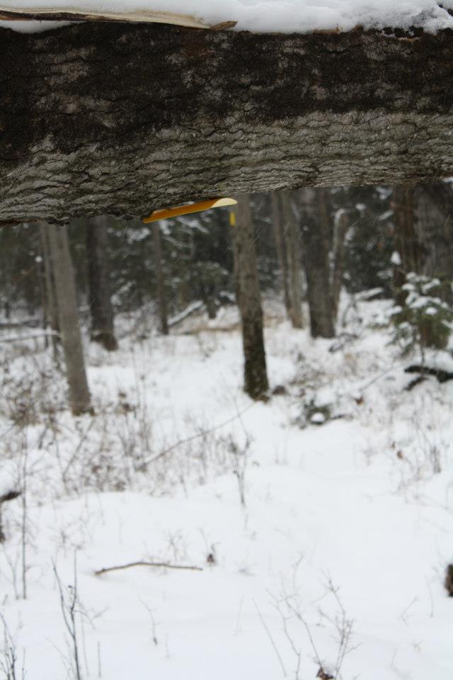
But on our return trip from downstate visiting family for Christmas, I got a hankering to get back out there and so Friday morning, I packed my Camelbak with my GPS, a hunting knife and a small lunch, grabbed my bike and put it in the trunk of my car, threw in my snowshoes just in case the snow on the trail was deeper than expected and headed east. To get where I am currently at, there really isn't any easy way to get there. First I head south on Hwy 53, then east on 64, then north on County E which heads up into the Nicolet-Chequamegon National Forest in Taylor County, then east again on Mondeaux Avenue until reaching the far side of the Mondeaux Flowage. Back in January I had hiked the trail that skirts the Flowage on a beautiful, sunny day. But yesterday, snow lightly fell as I stashed the bike at the trail's exit on Shady Drive about 4 miles away. I then doubled back to Mondeaux Drive (FR 104), threw on my snow pants, donned my Woverine boots, grabbed my walking pole, put on my Camelbak and began my 53rd hike along the IAT.
There was perhaps 2-3 inches of snow on the trail, certainly nothing meriting snowshoes so I left those behind in the car. There was absolutely no wind and with the snow lightly falling a stillness was on the wood. The only sound was the swooshing my snowpants made as they rubbed together as I followed the trail that meandered lazily around pine and scrub oak. At one point, I reached a swampy area - a pleasant change of scenery after walking perhaps a mile or so in the trees. At one point, a single board bridge was the only means to traverse one narrow section of the swamp. The birds were quiet and while there was plenty of tracks of rabbit, deer and other forest critters (including a snowshoer or two who had been through in the last day or two), it felt like I was the only one alive in the wood.
About an hour and forty-five minutes into the hike, I stopped under a large grove of white pine for my noon repast. There really wasn't any place to sit down and having worked up a sweat I was really wishing I had remembered to pack a small thermos of coffee now that I was cooling down. I really like my Camelbak save for the fact that the supply tube freezes easily making it pointless to lug 1.5 litres of water on my back just for the sake of doing it. I grabbed snow that had gathered atop small evergreens for my water. After about 15 minutes, I resumed my trek.
A little ways following where I had stopped for lunch, I crossed a forest road that didn't appear on my map. Once on the other side I began to see less pine and more oak, hemlock and the like. This segment of the IAT concludes with a long, gradual climb up the last esker in what is officially referred to as the Mondeaux Esker Segment (see pg. 141 in the Ice Age Trail Companion Guide 2004 edition). By about 12:45, I exited the woods and walked out onto Shady Drive. Even though my bike was parked just inside the trail head, I had decided I would get a jump start on the road connector to the next segment. So I hiked the half mile or so down to Zimmerman Road and then turned around headed back to the bike.
Now the trickiest bit of the hike began - the journey back. Riding my Fuji on snow-covered roads without studs in my tires was challenging enough but trying to do so without wiping out and not tearing the inside seam of my right snowpant leg on the sprockets of my bike chain was a bit dicey. Fortunately, I made it back to the car without incident (although my right snow pant leg got torn pretty noticeably by the chain of my bike) by 2 p.m. Were this not a winter's day, it would be too early to head back having come all this way for what amounted to a 4 mile hike. But given that the afternoon was waning, I decided to play it conservatively and head for home.
When I got home around dinner-time Friday night, I was tired (I think more from my bike ride than from the hike itself.) But yesterday, as I loaded my pictures onto my Facebook page, I felt renewed in my desire to hike the trail in its entirety. It's gonna take awhile but a quiet walk in a snowy wood makes it all worth while.
Following my completion of the Gandy
Dancer State Trail Segment (see last post, Hikes 4-7), I headed down 150th
Street to the entrance to the Trade River CC Ski Trail.
Trade River Segment
Some of the scenery on 150th St
Near the entrance of the Trade River Ski Trail
I'm glad they groomed it for me
Fortunately
for me, it had been recently mowed which made traversing it
relatively easy. What's more, after four successive hikes on the
Gandy Dancer, the change in scenery was a welcome sight. Some of the
IAT in this segment runs on private land easement and at least on the
afternoon that I hiked this section there were parts of the trail
that were barely kept up. (Note to prospective hiker: It's always a
good thing to go to the Ice Age Trail Alliance [or IATA] website and
check on trail conditions of the section you are interested in hiking
BEFORE you hike. Trust me. I know. Here's the link to the IATA website
) It was only early June and the grass, in some places, was already
up to my waist.
Somebody's tree stand
My brother-in-law says this reminds him of Andrew Wyeth painting without the girl
Too bad they weren't around
I stopped for a break in the shade of a tree on the
grounds of the Seventh Day Adventist Church on 140th
Street and I can still recall thinking, “I should have brought more
water.” Too bad it wasn't Saturday. There would have been some
Adventists around so that I could have got a refill on my water
bottle.
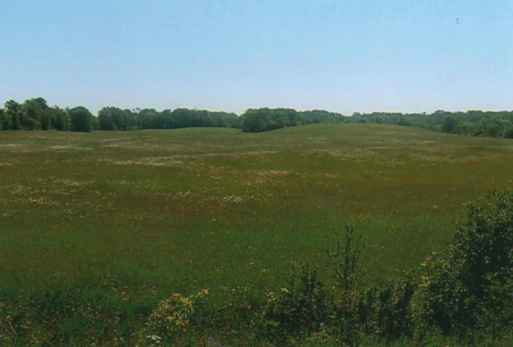
The field of blood (as in mine)
There is a large field that the IAT
crosses before it enters the woods that is officially part of
Straight Lake State Park. On that day it was a tick's paradise as I
pulled several off of me that afternoon during my hike as well as a
few more when I got home that night.
The Trade River
There is a wooden footbridge
that crosses the Trade River. As rivers go, it's a pretty quite one.
It fact, it looks more like a stream to me – but then again it was
a warm day in June when I crossed it. The Trade is a tributary of the
St. Croix River that runs for nearly 50 miles. Apparently at times it
has also been known by the names Atanwa or Ottoway River both of
which are Anglicized versions of an Ojibwe word for “trade” (Got
that little tidbit from this Wikipedia article .)
The footbridge over the Trade
Trade River
The large erratic
A little way past the footbridge I came
upon the large erratic that stands along the IAT on the Lundberg
property. According to the IAT Companion Guide (2004 edition),
this large monstrosity got moved here by the Superior
lobe...well, a long time ago. I noted in my journal that night that
“The erratic is
something to behold but it was so buggy in the woods I kept on
going.” I
did. I can't remember if I had forgotten to apply some bug spray or
it wasn't strong enough to hold off the all out blitz they sent at me
in the woods. The Guide says the IAT also passes an ancient beaver
dam but if it does I missed it entirely. The last section of this
segment passes through another easement on farmland. By the time I
got to my bike it was mid-afternoon, I was thirsty and now I had 3-4
mile bike ride back to my van. Note to self: always bring more water
than you think you will need.
Stretching 98 miles between St. Croix
Falls and just west of Pattison State Park near Superior is the
multi-use, crushed limestone surfaced trail known as the Gandy Dancer
Trail (here's the link to the DNR webpage, Gandy Dancer Trail). It's one of the many
“rail-to-trail” recreational projects that pepper the state.
According to the Gandy webpage, it takes its name from the crews who
laid the track back when railroad was king. These laborers used tools
made by the Gandy Tool Company of Chicago. “The crews were known to
work by keeping their voices and the movement of their feet and tools
in harmony.” And thus the term “Gandy Dancers” was coined.
Check out this brief video I found on YouTube:
From just south of Centuria to just
north of Luck, the IAT runs quietly along the GDT. Between January
and June of 2006, I hiked this segment (appropriately called the
Gandy Dancer State Trail Segment.) It's only 13 miles and really even
an amateur hiker could cover that distance easily in two hikes. But
my life as husband, father of four and pastor has an uncanny way of
interrupting my best laid plans for hiking. As I mentioned in an
earlier post, at the rate I'm going six years into my quest I really
will be an old man by the time I reach the Eastern Terminus in
Potawatomi State Park. Hiking this segment is a case in point. It
took me four hikes to cover 13 miles. That's what I call pedestrian
pace.
Hike 4: Thursday, January 26, 2006
160th Ave to 180th
Ave
My journal says it was yet another
awesome spring-like January afternoon. The week before that I had
been out on the trail I had dealt with an Alberta Clipper in my face
the entire length of the 4 1/2 mile road connector walk. The only
upside was that when I got to the bike, that Clipper was at my
backside pushing me all the way back to my van. On this day, however,
a strong Chinook from the southwest was blowing. For the third time
in as many weeks, I drove up Highway 35 to Centuria to stash the bike
a mile north of town and then drove back about mile south to the
Fristad Lutheran Church cemetery located about a half mile from the GDT. I brought
along my snowshoes but the warm weather and had reduced the snow
cover on the trail to the extent that it really wasn't necessary. In
fact it was overkill, really just an excuse to say that I got some
use out of them.
I got a late start (a little after 2
p.m.) and I only planned a 2-mile hike simply because I probably had
to get to my son's wrestling match that was somewhere in the area.
According to the IAT Companion Guide, the GDT is located on a glacial
outwash plain which was formed back in Ice Age days when glacial
meltwater streams in front of the glacier spread over a very wide,
flat area. Not only does it make it great for farming that also
translates into zero elevation for hikers. Even someone with a walker
could easily make this stretch.
My hike was fairly uneventful except
for the sighting of a large, black dog or something wild several
hundred yards ahead of me and later in a field adjacent to the IAT.
When I reached 180th Ave, I tried to carry my snowshoes in
my backpack as I pedaled back to the van but that proved to be too
cumbersome. I had to stash them somewhere, ride back, and then drive
back up the road to pick up the shoes. It was on that return trip
(not to be confused with the bike-return trip) that I found that the
wild thing I had spotted turned out to be a large black, herd dog who
apparently was out on the town on a beautiful winter afternoon.
Hike 5: Thursday, March 9, 2006
180th Avenue to Milltown
I didn't have a chance to get back out
on the IAT until March but once again it was a 40-something degree
day. The scenery was much the same as I encountered in Hike 4 mainly
farm fields and scrub trees that have grown up along the former Soo
Line. Here's a few lines from my journal entry for this hike:
“The winter birds were out –
cardinals, blue jays, chickadees, woodpeckers – and I even heard a
Baltimore Oriole. The unfortunate part of this section of the IAT is
its proximity to Hwy 35. This means its difficult to hear the birds
above the din of the traffic. But it was an awesome day to be out –
even if the hike only lasted a little under 2 hours.”
Milltown
Milltown is a small
village of about 800 people which hosts three community festivals:
Fisherman's Party (June), Pumpkin Fest (October) and Santa Day
(December). There must be a story behind Fisherman's Party given that
there is no lake in the direct proximity of the town. The GDT splits
the village neatly in two.
Hike 6: Thursday,
June 8, 2006
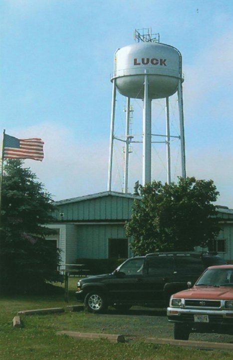
Milltown to Luck
As I recall it,
during a very busy week of Vacation Bible School, my wife, Linda, and I managed to
squeeze in a “hike-and-bike” pn the GDT. The longer days of early
summer certainly afforded us more daylight and we didn't get out that
way until mid afternoon. We dropped our bikes off in Luck and then
drove back to Milltown. This is one of the things I wrote in my
journal that day: “It was a pleasant walk on a fairly boring
part of the IAT. But the company was good.” It was indeed. We
saw lots of chipmunks and squirrels and just outside of Luck we
stirred up a crane who was fishing in the stream connecting Big and
Little Butternut Lake. By the time we arrived it was dinnertime and
so we walked to the Hog Wild BBQ & Grill in downtown Luck and
enjoyed a good meal. When I first started running back in 2000, I
would travel over to Luck to run the “In and Out of Luck 10K”
they always ran near St. Patrick's Day and the “Leg it in Luck 5 &
10K” right before the 4th of July. Unfortunately, both
races have gone the way of the dodo. While writing this post I spent
a little time searching for the reason the town got its name. If
there is a reason, none of the locals will say given that it's not
found on either the Village's or the Community Club's website.
Unbeknownst to me until this search, however, is that Luck's claim to
fame was that the Duncan Company, maker of the famed yo-yo –
several of which I played with when I was a kid – had a plant here
for many years. (It's also the place of where the church I pastor got
its pews way “back in the day”.)
Some of the wildlife on the trail
After dinner, we
walked back to our bikes and then rode the 3 1/2 miles back to our
van. “All in all it was a wonderful late afternoon stroll with
my best friend and lover” is what I recorded in my journal that
night. This was the first of many journeys that Linda would accompany
me during the first few years on the IAT.
The ribs weren't the only thing that were hot at the Hog Wild BBQ & Grill
Hike 7 (Part 1): Wednesday,
June 14, 2006
Luck to Highway 35
It felt so good to
be back on the trail (before my last hike the week before I hadn't
been on the IAT for nearly three months) that I decided to “combine
pleasure with pleasure” the following Wednesday. It was a
beautiful day and I engaged in what one man refers to as “long
winding prayer” or essentially hiking and praying simultaneously.
I left Luck around
9 a.m. and had the trail virtually to myself. In fact, more often
than not, in the 250 plus trail miles I have logged since 2006, I am
all alone out on the IAT. Now that may have more to do that I usually
am hiking on my day off which happens to be a Thursday but if you
are seeking solitude, you can find it out here (if you
don't include the birds and wildlife you are more than likely to
encounter on a given hike, of course). That morning I played hide 'n seek with a
handful of deer. The colors of the wildflowers which were in full
bloom were just stunning.
“Just before the IAT parts from
the Gandy, there's a hidden ledge below the trail that crosses the
Trade River. I rested there awhile and then proceeded on my way. Just
south of Frederick at long last the IAT left the Gandy.”
I saw this guy several times that morning
Trade River
Right
before Highway 35 crosses over the GDT, the IAT segues to the east.
The rest of that journal entry I'll save for my next post. A strong
and fit person could probably do the entire 13 mile segment in one
full day – or less - but it took me four. It is fairly boring from
a scenic point of view but I enjoyed my brief rambles on the
GDT nonetheless.